fbpx

Cairns to Lautoka Expedition (Silver Expedition)

Cairns to Lautoka Expedition (Silver Expedition)

UTOSS
Call for Price

Description

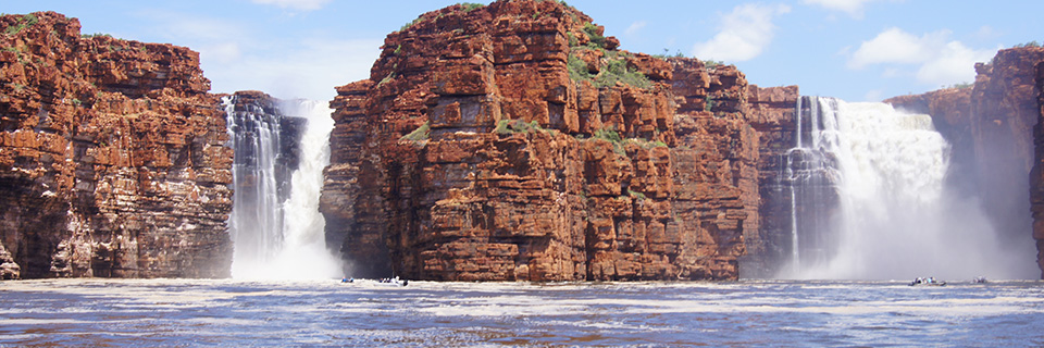
If the Great Barrier Reef was not already on your bucket list, then it is now. Join us as we follow the coral south to Middleton Reef and deep dive – literally – into an underwater world of prismatic beauty. If all the subaquatic activity gets too much for you, then you’ll enjoy the spectacular traditional dances on Vanuatu’s black-beached terra firma. A tale of islands in the blue, this is a true voyage to the ends of the earth.

Trip Name
Cairns to Lautoka Expedition (Silver Expedition)
Days
17
Overview
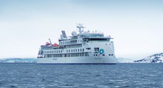
Vessel Type: Luxury Expedition Length: 108 metres Passenger Capacity: 144 Built / refurbished: 1989 / 2008 / 2018 Silversea’s purpose-built luxury Silver Explorer expedition cruise ship has been designed specifically for navigating waters in some of the world’s most remote destinations, including both of earth’s polar regions. A strengthened hull with a Lloyd’s Register ice-class notation (1A) for passenger vessels enables the Silver Explorer Expedition Cruise Ship to safely push through ice floes with ease. A fleet of 12 Zodiac boats allows Silversea Expedition guests to visit even the most off-the-beaten path locations and an expert Expedition Team provides insight and understanding to each unforgettable Silver Explorer luxury cruise adventure.

Itinerary


Day 1 - Day 1 Cairns
Warmly welcoming you to the natural wonders of the Great Barrier Reef, Cairns is a treasure trove of rich tropical beauty and incredible sea life. Swathes of rainforest spread out to the north, where you can soar over the canopy in a cable car, before looking down over narrow channels of water plummeting down gorges and crocodile-filled waterways. The diverse lands of the Atherton Tableland lie to the west, but it's the crystal-clear waters - and life-filled reefs - of Cairns' remarkable underwater world that draws universal adulation. Priding itself as the Gateway to the Great Barrier Reef, explore Cairns' constellation of colour, as you dive into the world's largest and most spectacular underwater universe. Head out on a glass-bottomed boat tour to explore the 3,000 coral reef systems, and let hours drift by appreciating the waving corals and life-imbued reefs during exceptional scuba diving and snorkelling sessions. Cairns is huddled in amongst abundant swathes of rainforests, which give way to glorious crescents of golden beach. Kuranda - with its scenic railway and heritage market stalls - waits to be discovered, cloaked within the depths of the rainforest. Learn of the indigenous people of North Queensland during cultural performances, and hear the throaty reverberations of digeridoos, as you hear eternal stories handed down through time, from generation to generation. Back in Cairns, there's always time for a coffee or a beer, or a feast on fresh oysters with glasses of Cairns' white wines – boldly flavoured with mango and banana notes.
Day 2 - Day 2 Holbourne Island
Holbourne Island is some 40 kilometers north of Bowen (Queensland) and is the most northern and remote island of the greater Whitsunday region. This continental island actually is a 33 ha national park and its surrounding waters are protected as a Marine Conservation Park, part of the Great Barrier Reef World Heritage Area. Holbourne Island National Park shows rocky escarpments, two sandy beaches and somewhat sheltered coral reefs. The vegetation ranges from vine thickets on the shore to grasslands and stunted shrubs on the hillsides with a small forest of Pisonia trees. The beaches offer nesting ground for green turtles and flatback turtles. From October to March coastal and migratory birds visit the reef flats and beaches as stopover points to roost, feed or breed during their annual migration. Terns, boobies, frigatebirds and noddies are most commonly seen, but Eastern Ospreys and White-bellied Sea-Eagle have been recorded, too.
Day 3 - Days 2 - 3 Whitsundays (Hardy Reef) & Airlie Beach
Hardy Reef is one of the many thousands of small reefs that make up the Great Barrier Reef and lies just off the Whitsundays coast of Australia. The coral wall of Hardy is home to an ecosystem of magnificent corals and marine life. Hundreds of fish species here will surprise and delight. Visitors have specific protected areas where they can swim and snorkel and marvel at the many underwater wonders, amongst them the giant groupers. There are other reef options in the area for swimming and snorkelling in the best possible location based on sea conditions.With the finest powder sand, knots of deep green rainforest and ankle-deep shelves of turquoise sea water - Airlie Beach is your gateway to some of the world’s most spectacular beaches. This lively town welcomes wide-eyed young adventurers and the yachting crowd alike to the Whitsunday Islands’ serenity, and the hiss of espresso machines, and excited chatter of adventure, spills out from its many cafes and bars. Relax at Airlie Beach Lagoon – the social hub of this town - where sun-heated saltwater invites you to wade, before flaming fresh coral trout over a barbecue as the sun sets. Or, take a seat at one of the glorious restaurants offering uninterrupted views out over the waters of Pioneer Bay, towards the 74 islands that make up the Whitsundays. These heavenly waters don't just attract humans. Humpback and pilot whales also migrate here to indulge in the warm waters and sheltered location. Spot the majestic creatures breaching and gulping in huge gasps of oxygen as you explore. Feeling adventurous? Rainforest walks to secluded pebble beaches await at Conway National Park, where difficulty-graded walking trails are available. Dive among swirls of jewel-coloured marine life, or experience the thrill of skimming into the sky on a seaplane. Take off to admire the scattered island paradises below from a stunning new aerial perspective, before landing and enjoying a picnic amid Whitehaven Beach’s bliss.
Day 4 - Day 4 Percy Island
a:0:{}
Day 5 - Day 5 Capricornia Cays National Park
The Capricorn Group and Bunker Group are two groups of islands and reefs extending parallel to Queensland’s coast some 80 kilometers northeast of Gladstone. These two groups are protected as the Capricornia Cays National Park. At the southern end of the Great Barrier Reef World Heritage Area, the beauty of the Capricorn-Bunker group of islands was one of the reasons the Great Barrier Reef was declared a UNESCO World Heritage Area in 1981. The natural integrity of the heavily vegetated cays contrasting with the blue reef waters and white coral sands is visually impressive, but these cays and islands are also important for seabirds and turtles. The park contains the most important offshore loggerhead turtle rookery on Australia’s east coast and research stations on Heron Island and One Tree monitor the conditions on land and in the sea. About 80% of Australia’s Pisonia grandis trees grow in the park and almost 75% of the Great Barrier Reef’s seabird biomass occurs in the Capricornia Cays National Park, with large groups of Wedge-tailed Shearwaters and Black Noddies prominent.
Day 6 - Day 6 At Sea
a:0:{}
Day 7 - Day 7 Middleton Reef
Middleton Reef is one of two reefs comprising the Elizabeth and Middleton Reefs Marine National Nature Reserve. This nature reserve was additionally declared a Ramsar Wetland of International Importance. Middleton is one of the southernmost open-ocean coral reef platforms in the world and the peak of one of the volcanic seamounts which form the Lord Howe Island volcanic chain. Only a small sand cay exists, but the few Common Noddies that breed at the reserve do so on one of the wrecks. The reef is some 555 kilometers due west of the Australian coast and some 220 kilometers north of Lord Howe. This remote location of Middleton and the combination of cold currents in winter and warm currents in summer have brought forth a number of endemics –it contains the last known large population of black cod and more than 300 tropical and subtropical fish species have been registered. The sea here is a nursery habitat for open-water fish and the area around Middleton and towards Elizabeth Reef has been declared a Sanctuary Zone where neither commercial nor recreational fishing is allowed. Although already seen and named in 1788, the kidney-shaped reef still poses a danger to vessels and shows a number of shipwrecks.
Day 8 - Day 8 At Sea
a:0:{}
Day 9 - Day 9 Norfolk Islands
a:0:{}
Day 10 - Day 10 At Sea
a:0:{}
Day 11 - Day 11 Mystery Island & Anelghowhat (Aneityum Island)
Inyeug Island, better known as Mystery Island, is part of the Tafea Province of Vanatu, the southernmost collection of islands. This is a picturesque island with large rounded cliffs jutting from the water. The cliffs create protected lagoons with some of the lightest, clearest waters in the world. The island is, with the exception of an airstrip used twice weekly, made up entirely of beaches and reefs. This place is ideal for relaxing, swimming and snorkelling in the tranquil waters, where many diverse tropical fishes hide between the corals.Vanuatu's southernmost inhabited island, Aneityum, is a little tropical island paradise. The interior of the island is mountainous and covered with forest and exists at a slightly cooler climate than the rest of the island. Aneityum rests upon two coalescing volcanoes, although volcanic activity ceased long ago, during the late-Pleistocene to Holocene era. Along the coast, pine plantations contrast with coconut palms, white sand beaches and coral reefs. Aneghowhat is the main settlement on the southwestern side of Aneityum, though it is a small and simple town, as the entire island only has a population of approximately 900 people.
Day 12 - Day 12 Aniwa Island & Waisisi (Tanna)
Aniwa is a small uplifted coral platform in the southernmost province of Vanuatu. A vivid coral reef has formed here in recent times and grows now where tongues of lava once overran the volcanic slopes and flowed into the ocean. As the corals, sponges and anemones overgrow the dark lava rock, schools of vivid reef fish cruise above.Waisisi is a bay and a village located on Tanna’s eastern shore. The black sandy beach –an indication of the volcanic activity of the island- and the lush forest belie the fact that this has been an important site in the White Sands region. A famous war was fought here and a tree planted to mark the end of it can still be seen. This area is also home to the John Frum Cargo Cult. Waisisi will be the gateway to see Mount Yasur -the most accessible explosive volcano in the world. Locals believe their spirit god dwells in there so it is a sacred place to the local tribes. The volcanic firework display at sunset is awe-inspiring.
Day 13 - Day 13 Makura Island
Conjuring up a tropical island might well bring to mind the island of Makura in the Shepherds Islands of Vanuatu. Makura is small, but it is actually the peak of a primeval volcano. The other existing ramparts of the volcanic rim are believed to be the neighboring islands of Emae and Mataso. Roughly 3,000 people call the Shepherds Islands home and Makura Island is one of these populated islands. The easy-going islanders live in a small village on the northwestern part of the island amidst a rugged volcanic backdrop.
Day 14 - Day 14 Ambrym Island
Unlike Espiritu Santo with its raised coral reefs and white sand, Ambrym is a volcanically active island with dark sand beaches. Ambrym is known as the island of magic and is the source of five local languages that all evolved on Ambrym. This handful of languages contributes to the well over 100 languages of Vanuatu. Some of Ambrym’s magic takes place in the lush greenery of the local community of Ranon. Here the people perform a very special and traditional ‘Rom’ dance. Participants prepare their masks and costumes in secrecy and the dance is reserved for special occasions.
Day 15 - Day 15 At Sea
a:0:{}
Day 16 - Day 16 Sawa-I-Lau
Part of the northern Yasawa Islands, Sawa-i-Lau is just south of the archipelago’s largest island, Yasawa. Access to the island is via Buasali Bay with Tamasua and Nabukeru being the closest villages. Part of Nabukeru’s families are the owners of Sawa-i-Lau. Unlike the other, major islands which are of volcanic origin, Sawa-i-Lau is an impressive limestone island with steep sides rising high into the air. At its western shore a small beach permits access via some concrete steps to the main attraction: several remarkable caves. Once one has passed the door guarding the entrance to the island’s interior, shafts of light illuminate a dome-shaped cave connected underwater to the ocean. Apart from enjoying the natural pool which has a depth of some three meters, intrepid swimmers/snorkelers can head for a second cave which has to be accessed via a low tunnel which at high tide is below water level. Unlike the first cathedral-like cave, this has a low ceiling actually very close to the water. If this second cave already will be off-limit to most, the third cave can only be reached swimming through a long passage hidden in one of the second cave’s corners some six feet below the water’s surface. Similar to Mariner’s Cave in Vava’u, Tonga, the stories go that a young chief once had to hide his girlfriend inside Sawa-i-Lau’s caves, bringing her food on a daily basis until they could eventually escape to a different island.
Day 17 - Day 17 Lautoka
It doesn’t get much sweeter than arriving on the sun-soaked shores of the Sugar City. Fiji’s second-biggest settlement opens up a world of blissful beaches and turquoise seascapes, while its dense jungle lures the adventurous deep into its embrace. Step ashore where the first Fijians landed, and you'll understand instantly why they chose to make this island paradise their heavenly home. Experience rich Fijian life, and see dramatic displays like warrior dances, and remarkable local practices like firewalks, which kick up burning embers into the night's sky. Legend says the city took its name after two chiefs faced each other in a duel. A spear pierced one of the chiefs, leading to the shout of 'lau-toka!' or 'spear hit!' Sugar is Lautoka’s main trade, but its botanical gardens are a sweet insight into the tropical plant life that thrives here - from pearl white lilies to tall, fragrant orchids. Explore temples, charming cafes and mills - or barter for some of the juiciest mangoes you’ll ever taste at the city’s lively market. You'll only be able to resist the beaches for so long, and it doesn’t get much more stunning than the Blue Lagoon - a heavenly blend of woven together turquoise shades. Remote, wild and unspoiled, these are some of the best tropical beaches in the world. There's more rejuvenating relaxation at the mineral-rich mud pools and spas, fuelled by the volcanic activity below. Savala Island is a teardrop of sand offshore, and another beautiful place to wander with the soft powder between your toes - along sandy spits that peter out into the water. Or swim and snorkel among its envied reefs, thronging with fish life.
Day 18 - Please Note:
Itineraries are subject to change.

Trip Dates

StartEndPrice FromRoom Type

Inclusions

    • Visit small island communities to experience Melanesian welcomes
    • Witness Vanuatu’s spectacular traditional dances
    • Learn about the grim history of Norfolk Island and perhaps meet descendants of the Bounty mutineers.
    • Meet members of Vanuatu’s John Frum cult.
    • Common White Tern, Lesser Frigatebird, Brown Booby, Masked Booby, Red-footed Booby, Brown Noddy, Pacific Reef Heron, Red-tailed Tropicbird, Wedge-tailed Shearwaters, Norfolk Parakeets
    • Dolphins, humpback whales, minke whales, sei whales
    • Feather stars, colourful nudibranchs, vase sponges, gorgonian fans, lionfish and octopi, and many reef fish

Map