fbpx

Nome to Tromso: Arctic Expedition Cruise

Nome to Tromso: Arctic Expedition Cruise

OMOSS
Call for Price

Description

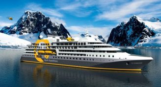
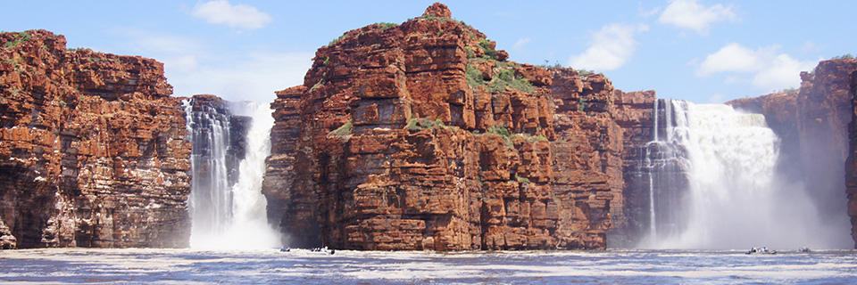
Join us for Silversea’s second crossing of the Northeast Passage, retracing the voyages of famous explorers like Nordenskiöld, Nansen, DeLong and Amundsen! See how far north Silver Explorer can get and visit islands few people have even heard of. You will be amazed by the dramatic scenery and the resilient wildlife of the Russian High Arctic with a chance to spot walrus and polar bears in this harshest of landscapes.
Encounter fascinating local cultures in Chukotka and visit Wrangel Island, home to thousands of walrus and polar bears.

Throughout the voyage, learn about the history, geology, wildlife and botany of this spectacular area from lecture presentations offered by your knowledgeable onboard Expedition Team.

Trip Name
Nome to Tromso: Arctic Expedition Cruise
Days
27
Overview
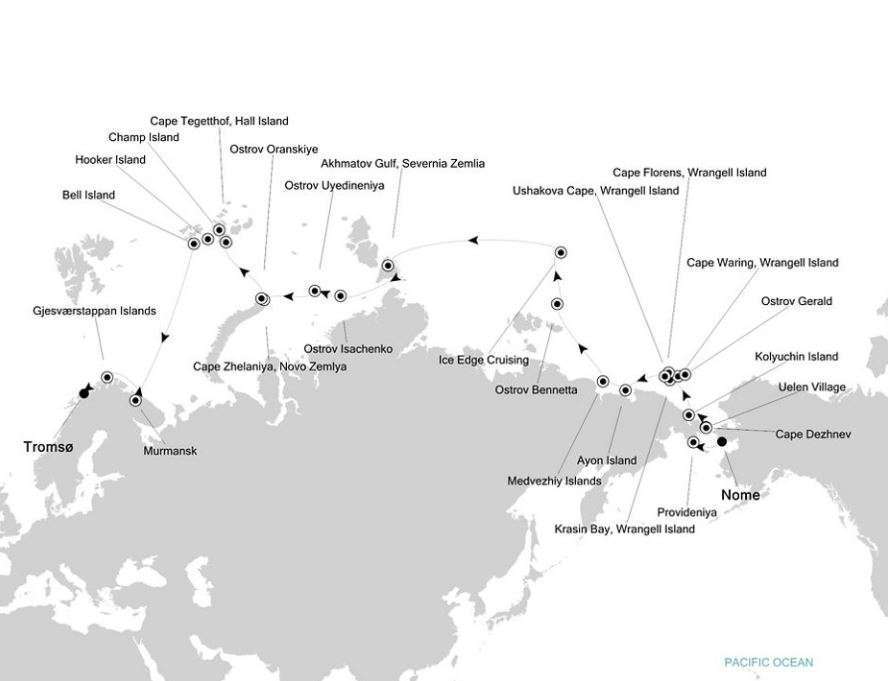
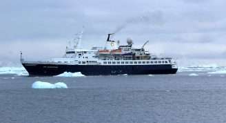
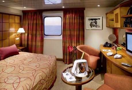
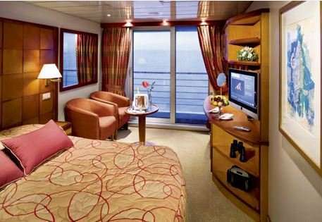
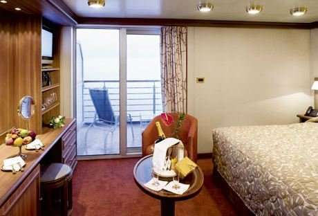
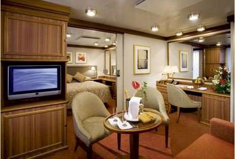
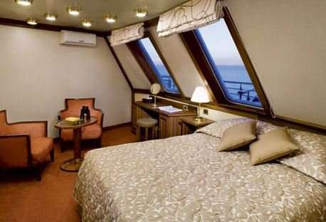
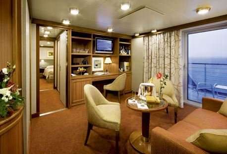
Vessel Type: Luxury Expedition
Length: 108 metres
Passenger Capacity: 144
Built / refurbished: 1989 / 2008 / 2018
Silversea’s purpose-built luxury Silver Explorer expedition cruise ship has been designed specifically for navigating waters in some of the world’s most remote destinations, including both of earth’s polar regions. A strengthened hull with a Lloyd’s Register ice-class notation (1A) for passenger vessels enables the Silver Explorer Expedition Cruise Ship to safely push through ice floes with ease. A fleet of 12 Zodiac boats allows Silversea Expedition guests to visit even the most off-the-beaten path locations and an expert Expedition Team provides insight and understanding to each unforgettable Silver Explorer luxury cruise adventure.

Itinerary


Day 1 - Day 1 NOME (ALASKA)
Nome is located on the edge of the Bering Sea, on the southwest side of the Seward Peninsula. Unlike other towns which are named for explorers, heroes or politicians, Nome was named as a result of a 50 year-old spelling error. In the 1850's an officer on a British ship off the coast of Alaska noted on a manuscript map that a nearby prominent point was not identified. He wrote "? Name" next to the point.
Day 2 - Day 2 DATE LINE LOSE A DAY
a:0:{}
Day 3 - Day 3 PROVIDENIYA
Provideniya is a former Soviet military port at the southern limit of the Arctic ice pack. With slightly less than 2000 inhabitants, many of whom are Yupik, it is the largest town and administrative center of the Providensky District. Started as a depot for the Northeast Passage traffic, it now is a port of entry to the Russian Far East and since the decline of the Soviet Union eco-tourism has boosted the local economy. The town has a Technical School and a fascinating museum with interesting and well-presented exhibits about the natural history and wildlife of the region.
Day 4 - Day 4 CAPE DEZHNEV & UELEN VILLAGE
Located between the Chuchki Sea and the Bering Sea, Cape Dezhnev comprises the easternmost mainland point in all of Eurasia. The cape was originally named East Cape by Captail James Cook, but has since been renamed for Semyon Dezhnev, the first recorded European to round its peninsula. The cape is the edge of a rocky headland with steep, carved-looking cliffs. Ashore can be found one of Russia’s most famous lighthouses and the monument honouring Dezhnev. The cape was a center for trade between American and European whalers, as well as fur traders.Located north of Cape Dezhnev in Chukotka along the Bering Strait, the small coastal village of Uelen is the furthest east settlement in all of Eurasia (and is also the closest Russian settlement to the United States). The village is near the Uelen Lagoon and is known by the local Yupik as “Land’s End,” and has a population of around 700 inhabitants. When during soviet times it had been decided to abandon many of the smaller settlements in favor of larger consolidated ones, Uelen was chosen as one of the four villages to take in the inhabitants of other settlements.
Day 5 - Day 5 KOLYUCHIN ISLAND
Kolyuchin Island is a small island in the Chukchi Sea that is uninhabited and covered with tundra vegetation. The island is the site of a famous rescue operation after a Russian icebreaker was crushed by ice nearby. Located close to the Siberian shore this island has been used as the base for a now-abandoned meteorological station at its western end, while walrus hunters had a few huts on the eastern side. The island has steep, dramatic bird cliffs teeming with Pelagic Cormorants, Thick-billed Murres and kittiwakes.
Day 6 - Day 6 KRASIN BAY (WRANGEL ISLAND)
Krasin Bay is one of several landing points to explore Wrangel Island, a UNESCO World Heritage Site rich with Arctic vistas and wildlife. Most noteworthy that can be seen from Krasin Bay are the remains of ancient inhabitants of Wrangel Island, a 3,400 year old Paleo-Eskimo camp. In addition, nature trekking to look for land mammals, birds and the varied flora is recommended. Wildlife sightings may include walrus, musk oxen, and possibly even polar bears.
Day 7 - Day 7 CAPE WARING (WRANGEL ISLAND) & OSTROV GERALD
Cape Waring is a dramatic approach to Wrangel Island, an important nature reserve on the Chukchi Sea and a UNESCO World Heritage Site known for its Arctic beauty and diverse wildlife and flora. Sail between blue and white ice floes, approaching a rocky cliff covered in seabirds and hugged by low-lying clouds. The ice floes are a favorite hang-out spot for walrus as well as seabirds such as Brunnich’s guillemots (thick-billed murres), petite and hearty black-and-white water birds.Ostrov Gerald is a small, isolated granitic island in the Chukchi Sea, less than 40 nautical miles to the east of Wrangel Island. It was named after a survey vessel, the HMS Herald, which visited the island in 1849 while searching for the vanished expedition of Sir John Franklin, and it’s English name is in fact, Herald Island. Steep cliffs ring the island in all but one slim area of accessible shoreline at the northwestern point of the island. Here the cliffs have eroded into piles of rock and one can find the only possible landing spot on this unglaciated, remote, and uninhabited island.
Day 8 - Day 8 WRANGEL ISLAND (USHAKOVA CAPE) & CAPE FLORENS WRANGEL ISLAND
Located in the Arctic Ocean between the Chukchi Sea and East Siberian Sea, Wrangel Island is worth a longer visit to experience the Arctic wildlife that resides here. This protected nature area and UNESCO World Heritage Site has the largest amount of polar bears and apparently was the last place where woolly mammoth roamed. The name of the island goes back to the search for land north of the Chukchi Peninsula by Ferdinand von Wrangel, who went in search of the island with coordinates but did not find it on his first expedition.Cape Florens is located on the less icy northeast edge of Wrangel Island. This bay offers access to tundra nature walks, where visitors will tread upon permafrost and be able to explore the diverse and beautiful vegetation, including shrubs, sedges, grasses, mosses and lichens. This protected nature area and UNESCO World Heritage Site has a large amount of polar bears, which might be spotted if the timing is right.
Day 9 - Day 9 DAY AT SEA
Days at sea are the perfect opportunity to relax, unwind and catch up with what you’ve been meaning to do. So whether that is whale watching from the Observatory Lounge, writing home to your loved ones or simply topping up your tan by the pool, these blue sea days are the perfect balance to busy days spent exploring shore side.
Day 10 - Day 10 AYON ISLAND
Ayon Island is located off the coast of Chukotka at the eastern end of the Kolyma Gulf. Its size of 2,000 square kilometres permits the small local Chukchi population to herd reindeer. The local population welcomes the rare visitor with warmth and hospitality. The village of Ayon has a school with a museum that was put together by the children of the school. Displayed are mammoth tusks, stuffed birds and some Paleo Eskimo artifacts. The Russian polar station on Ayon Island is one of the few meteorological stations still in use and is staffed by 12.
Day 11 - Day 11 MEDVEZHIY ISLANDS
Also known as Bear Islands, the Medvezhyi are an uninhabited group of islands at the western side of the Gulf of Kolyma in the East Siberian Sea. It is not so much the bears, but the flora and geology that make these six islands stand out. This is a commercial fishing area despite the existence of fast ice that surrounds the islands during much of the year. On Chetyrokstolbovoy Island, flowers, lichen, mosses and mushrooms are abundant.
Day 12 - Day 12 DAY AT SEA
Days at sea are the perfect opportunity to relax, unwind and catch up with what you’ve been meaning to do. So whether that is whale watching from the Observatory Lounge, writing home to your loved ones or simply topping up your tan by the pool, these blue sea days are the perfect balance to busy days spent exploring shore side.
Day 13 - Day 13 OSTROV BENNETTA
Ostrov Bennetta in Russian, or Bennett Island as it is known in English, is the largest of the De Long group of islands located in the northern extents of the East Siberian Sea. Mount De Long dominates Bennett Island and is the highest point in the archipelago topping 426 meters (1,398 feet). The frosty white landscape of Bennett Island is the largest permanent ice cover within the De Long Islands. In recent years scientists have been able to map four separate glaciers forming the solid ice cap of this island.
Day 14 - Day 14 ICE EDGE CRUISING
Imagine being surrounded on all sides by glistening sea ice on top of dark, frigid waters. The sound of the ship’s bow crunching through the crusty rime carries on the crisp air with a resounding echo. Perhaps in the distance the expedition team spots an inconsistency of color on the ice – a vaguely yellow patch against the bright white of the snow. Excitement on deck grows as the ship draws closer, and with baited breath it becomes obvious to all aboard that a polar bear is plodding along, jumping from floe to floe, in its eternal quest for the next meal.
Day 15 - Day 15 DAY AT SEA
Days at sea are the perfect opportunity to relax, unwind and catch up with what you’ve been meaning to do. So whether that is whale watching from the Observatory Lounge, writing home to your loved ones or simply topping up your tan by the pool, these blue sea days are the perfect balance to busy days spent exploring shore side.
Day 16 - Day 16 AKHMATOV GULF (SEVERNIA ZEMLIA)
Akhmatov Gulf is also known as Akhmatov Bay and Akhmatov Fjord. It is a deep, glacially carved arm that runs almost mid-way through the mass of Bolshevik Island, the southernmost island of Severnaya Zemlya in far northern Russia. The fjord has a wide mouth (approx. 9 nautical miles across) on the island’s northeastern side and is clogged by ice much of the year. Steep, ice-polished mountain slopes drop into the water on either side of the broad channel.
Day 17 - Day 17 OSTROV ISACHENKO
Isachenko is an island of the Kirov group in the Kara Sea north of Russia. A level beach, under the right conditions, can provide a landing site for access to this remote island. Ashore, it is possible to see a deserted station, the operation of which was likely discontinued in 1993. Evidence of the station’s abandonment is everywhere with scattered pieces of equipment and a host of other materials left behind by the station crew in the now slowly decaying huts.
Day 18 - Day 18 OSTROV UYEDINENIYA
Uyedineniya Island, Lonely Island or Solitude Island, as it is also known, is located in the Kara Sea between Novaya Zemlya and Severnaya Zemlya. The small, relatively flat island’s tundra, when free of ice and snow, grows green vegetation in the summer. In addition to tundra, there are bogs and small lakes on the island. A long spit of land dominates its northeastern side and ice floes are commonly found in the waters here, even in the summer.
Day 19 - Day 19 CAPE ZHELANIYA (NOVO ZEMLYA) & OSTROV ORANSKIYE
The Russian word, Zhelaniya means 'wish,' and leads one to wonder why such a poetic name was ascribed to this remote headland on the northern end of Severny Island, part of Novaya Zemlya in the Russian Federation. The cape is an important geographical landmark although quite a desolate and exposed location, especially in the bitter Arctic winters. It is the physical point of reference that marks the boundary between the Barents Sea and the Kara Sea.Located a few nautical miles north of Cape Zhelaniya at the northern tip of the massive island of Novaya Zemlya lies tiny Ostrov Oranskiye; one of a small group known as the Orange Islands. Willem Barentz, a Dutch navigator sailed this region in the late 1500s on the small ship Mercury. The Mercury was one of three ships attempting to enter the Kara Sea in order to find the Northeast Passage above Siberia. It is reported that the Mercury’s crew discovered a massive herd of walrus on the Orange Islands and proceeded to attack them with hatchets and pikes to harvest their fabulous ivory tusks.
Day 20 - Day 20 CAPE TEGETTHOF (HALL ISLAND)
Over 190 islands complete the Franz Josef Land group, covering an area of more than 16,000 square kilometers. Hall Island is one of many islands in the archipelago that is almost totally covered by glaciers. Its highest point is over 500 meters, and is located on top of an ice dome. Cape Tegetthoff is a headland on the south end of Hall Island, one of the largest islands in the Franz Josef Land group. Hall Island was named after American Arctic explorer Charles Francis Hall.
Day 21 - Day 21 CHAMP ISLAND & HOOKER ISLAND
In the Franz Josef Land archipelago, an estimated 85% of the islands are glaciated. Champ Island is ice capped as well, but probably best-known by the few people who have had the opportunity to visit, for its rounded stone geodes, an almost unique phenomenon, even on a world-wide scale. At Cape Triest numerous geodes are partly stuck in the crumbing rock faces. A geode is sedimentary in origin, and is essentially a hollow, spherical mass of mineral matter that often forms with crystals in the center.Hooker Island is located in the heart of the Franz Josef Land archipelago, deep in the Arctic Ocean. A small bay provides an anchorage that can be busy with seabirds from nearby bird cliffs. Rubini Rock in Tikhaya Bay is an impressive rock formation with an intricate surface structure of curved basalt columns. Stark color contrasts are enhanced by bright lichens and lush green summer vegetation in less steep parts of the island.
Day 22 - Day 22 BELL ISLAND
The Franz Josef Land archipelago was first spotted by Norwegian sealers in 1865. The climate is severe most of the year with the average summer temperature around 35° F (2° C). Sparsely vegetated by lichens, mosses, and a few species of Arctic flowering plants, islands like Bell Island can be home to mammals including polar bears and the Arctic fox, with the potential for numerous seabird species to be nesting on the island. Bell Island is located in the western portion of the island chain and is home to the historic hut of explorer Benjamin Leigh Smith, dating back to 1881.
Day 23 - Days 23 - 24 AT SEA
Days at sea are the perfect opportunity to relax, unwind and catch up with what you’ve been meaning to do. So whether that is whale watching from the Observatory Lounge, writing home to your loved ones or simply topping up your tan by the pool, these blue sea days are the perfect balance to busy days spent exploring shore side.
Day 24 - Day 25 MURMANSK
The last city founded by the Russian Empire, Murmansk has long been an important ice-free naval and commercial shipping port. The smoke stacks, port cranes, and Soviet-era architecture are unappealing, but the natural surroundings draw visitors to ski and snowmobile in winter, and in summer to fish the thousands of lakes and rivers, and party away the long, light nights.
Day 25 - Day 26 GJESVARSTAPPAN ISLANDS
Almost a hundred islands and rocks make up the Gjesvӕrstappan Nature Reserve, one of Europe’s largest and most accessible nesting areas for Atlantic seabirds. Less than 10 nautical miles from Nordkapp more than one million nesting birds have been counted on Storstappen, the largest of the islands, and the minor islands next to it. One of the most significant Atlantic Puffin colonies in North Norway is found in this nature reserve.
Day 26 - Day 27 TROMSO
Tromsø surprised visitors in the 1800s: they thought it very sophisticated and cultured for being so close to the North Pole—hence its nickname, the Paris of the North. It looks the way a polar town should—with ice-capped mountain ridges and jagged architecture that is an echo of the peaks. The midnight sun shines from May 21 to July 21, and it is said that the northern lights decorate the night skies over Tromsø more than over any other city in Norway.
Day 27 - Please Note:
Expedition highlights and itinerary listed here are possible experiences only and cannot be guaranteed. Your Expedition Leader and Captain will work together to ensure opportunities for adventure and exploration are the best possible, taking into account the prevailing weather, wildlife activity and ice conditions. Expedition Team members scheduled for this voyage are subject to change or cancellation.

Trip Dates

StartEndPrice FromRoom Type

Inclusions

    • Discover Cape Dezhnev and Uelen Village, Wrangel Island, Medvezhyi Islands, Novaya Zemlya, Champ Island, Hall Island, Hooker Island, Murmansk, Gjesverstappan Islands
    • See cultural presentations in Provideniya and Uelen village, highlighting Russian and local folklore.
      See the bone carvings and the whale bone museum in Uelen

    • Wildlife Watch List: Polar bears, reindeer, musk oxen, Arctic ground squirrel, snow hare, Pacific walrus, ringed seals, ribbon seals, spotted seals, bearded seals, Humpback whales, grey whales, bowhead whales, beluga whales and white-beaked dolphins, Birds of note: Northern Fulmar, Short-tailed Shearwater, Northern Gannet, Horned Puffins, Tufted Puffins, Atlantic Puffins, Great Skua, Black-legged Kittiwakes, Red-legged Kittiwakes, Black Guillemots, Pigeon Guillemots, Common Guillemots, Parakeet Auklet, Least Auklet, Snow Buntings, White-tailed Eagles, Great Cormorants

Map